CARTOGRAPHY

[Sir Sidney Gerald Burrard (1860-1943), Surveyor General of India.] Large printed coloured map of ?Tibet and Adjacent Countries?, during the First World War.

Author: 
?Tibet and Adjacent Countries?: Sir Sidney Gerald Burrard (1860-1943), Surveyor General of India; Survey of India
Publication details: 
?Compiled under the direction of Colonel Sir S. G. Burrard, K.C.S.I., R.E., F.R.S., Surveyor General of India, 1917?, ?Helizincographed at the Survey of India Offices, Dehra Dun.?
£560.00

The original item. On one side of a piece of a piece of paper roughly 70 x 100 cm, folded into a 10.5 x 15.5 cm packet of fifty panels. An attractive item, but in need of some attention: on brittle and discoloured paper, with several closed tears. The map was the work of Col. H. B. Hudson. A significant map, still cited in the Sino-Indian border dispute. For the background see 'Two Important Maps from the Survey of India', Geographical Journa, October 1915. First published in 1914, but the only copy of this 1917 version located in the National Library of Australia.

[Ecclesiastical atlas,1843, with maps by von Stülpnagel and letterpress by Wiltsch.] ‘Atlas sacer sive ecclesiasticus inde ab antiquissimis religionis Christianae propagatae temporibus usqe ad primordia saeculi decimi sexti'.

Author: 
Joanne Elieser Theodoro Wiltsch, Cand. Rever. Minist. [Johann Elieser Theodor Wiltsch] (1803-1873); Johann Friedrich von Stülpnagel (1786-1865), Prussian cartographer [F. D. Maurice; Queen’s College]
Publication details: 
Gothae, Sumptibus Justi Perths. MDCCCXLIII. [1843.]
£1,800.00

The full title reads: ‘Atlas sacer sive ecclesiasticus / inde / ab antiquissimis religionis Christianae propagatae temporibus usqe [sic] ad primordia saeculi decimi sexti, / respectu habito / Judaeorum per totum orbem dissipatorum nec non regionum a gentilibus ac Mohammedannis incultarum / singulis tabulis, / descriptus / a / Joanne Elieser Theodoro Wiltsch / Cand. Rever. Minist.’ A folio volume, with the five maps, each of which is double-page folio, all having borders and boundaries picked out in colours.

[ Port of Manchester. ] Pamphlet with eighteen-ship 'itinerary' of vessels present at a 'visit', accompanied by five maps [ 'Principal oil docks and installations with their road connections', 'Hinterland', 'Dockside Area' ], three of them fold-outs.

Author: 
[ Port of Manchester ] [ George Falkner & Sons Limited; Dunlop, Heywood & Co. ]
Publication details: 
[ Port of Manchester. ] George Falkner & Sons Limited, Manchester. With section dated 16 July 1959.
£180.00

Five maps, four of them fold-outs, together with duplicated text on two leaves, stapled into 8vo pamphlet of buff printed wraps with 'PORT OF MANCHESTER' and logo on the front, and printers' slug on back. In fair condition, lightly aged and worn. The five maps include three fold-outs: the first, coloured in blue and light and dark green, titled 'Principal oil docks and installations with their road connections' ('For particulars of sites on the Company's Estate application should be made to the Company's Land Agents | Dunlop, Heywood & Co.

British Army Boer War map of 'Melmonth [ i.e. Melmoth ]': 'Sheet No. 37' in 'Transvaal (Major Jackson's Series)'.

Author: 
Major H. M. Jackson, Royal Engineers [ Field Intelligence Department, Pretoria; Boer War map: Melmoth, Transvaal ]
Publication details: 
[ British Army ] Field Intelligence Department, Pretoria, 1901. 'Photo-lithographed - Pretoria - June 1901 | Mapping Section - Field Intelligence Dept - Army Head Qrs.'
£80.00

Photolithographically printed in black on one side of a 51 x 63 cm. piece of cloth, folding into a 16.5 x 11 cm. packet, in green printed cloth covers backed with card. In good condition, lightly-aged, with minor signs of age and wear. Cover reads: 'Transvaal. | (Major Jackson's Series). | Sheet No. 37. | Melmonth. | Field Intelligence Department. | Pretoria, 1901.' Signed in pencil on front cover 'G S Scovell | Cam Hrs.' In top left-hand corner of map: 'No. 37'. In bottom left-hand corner: 'Compiled in Surveyor General's Office - Pretoria underdirection [sic] of MAJOR H. M. JACKSON R.E. Mch.

Printed map, titled 'Indian and Eastern Engineer. | Key Plan, showing the disposition of the Ships of H.M. Fleet, assembled at Spithead on the occasion of the Diamond Jubilee Review, 26th June, 1897.' With 'Tabular Statement' on reverse.

Author: 
[Royal Navy Diamond Jubilee Review, Spithead, 1897; The Indian and Eastern Engineer, monthly magazine]
Publication details: 
'Indian and Eastern Engineer', Calcutta. 1897.
£180.00

Printed in black on both sides of a 36 x 53 cm piece of wove paper with watermark of 'W F & Co'. In very good condition, lightly-aged and folded three times. The 'Key Plan' is on one side, showing the disposition of the fleet on a map of the Portsmouth area, with a note of 'Foreign Men of War', 'British Battle Ships and Cruisers', '3rd Class Cruisers Gun Vessels and Torpedo Gunboats', 'Special Merchant Vessels', 'Destoryers & Gunboats' and 'Torpedo Boats'.

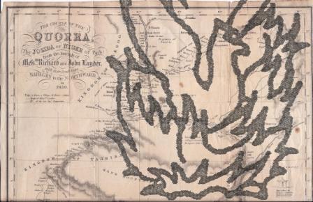
Map by A. B. Becher showing 'The Course of the Quorra, (the Joliba or Niger of Park) from the Journals of Messrs. Richard and John Lander. With their Route from Badagry to the Northward, in 1830.'

Author: 
Alexander Bridport Becher, 1796-1876 [Hugh Clapperton (1788-1827); Richard Lemon Lander (1804-1834); John Lander (1807-1839); Niger [Quorra] River, Nigeria; Africa]
Map by A. B. Becher showing 'The Course of the Quorra
Publication details: 
'A. B. Becher, del. J. & C. Walker, Sculpt.' [Produced to accompany the Journal of the Royal Geographical Society of London, vol. 1, 1831.]
£65.00
Map by A. B. Becher showing 'The Course of the Quorra

Approximately 27.5 x 31 cm. Printed in black and white, with relief shown by hill shading. A detailed map, showing the routes of the 1830 expeditions in Nigeria of the Landers' and of Captain Clapperton. Lightly aged, with closed tears unobtrusively repaired with archival paper. Small vignettes of 'Eboe House' and 'Hut called in Borgoo, Catambo.'

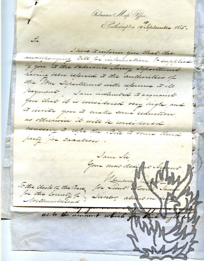
Secretarial Letter, Signed by Cameron, to Dickson, complaining that the latter's charges for work on the Ordnance Survey are 'very high'; ALS, 'Robt. H. Forman" of the War Department to Dickson; copies of Dickson's replies to both men.

Author: 
Major-General John Cameron, Director-General of the Ordnance Survey, 1875-1878 [William Dickson, Clerk of the Peace of the County of Northumberland; Alnwick]
Major-General John Cameron, Director-General of the Ordnance Survey
Publication details: 
London and Alnwick. All from 1855. Cameron's letter on letterhead of the Ordnance Map Office, Southampton.
£150.00
Major-General John Cameron, Director-General of the Ordnance Survey

All four items with text clear and complete. Good, on lightly-aged paper. The four items pinned together and placed in the stamped envelope of Cameron's letter, addressed to Dickson as 'Clerk of the Peace of the County of Northumberland | Newcastle upon Tyne'. Casting interesting light on the workings of the Ordnance Survey. Letter One: Cameron to Dickson ('for Lieut: Colonel James | Director, absent on duty'), 19 September 1855. 4to, 1 p.

Manuscript Map, in colours, by Corporal A. Hunter, of the 'Bilstien [sic, for 'Bilstein'] Defences. scale 1/6250'.

Author: 
Bilstein (Germany) [Junkermuehle, Nassenstein]
Publication details: 
01/02/19
£85.00

Dimensions of paper roughly. Creased, with fraying to extremities, closed tears, and some staining and fading due to damp. A careful production, detailing the fortification to the towns of Bilstein (north-east of Cologne), Junkermuehle and Nassenstein, in black, yellow, red and green, with attractive lettering. 'References' are to 'barbed wire entanglements', 'main roads', 'Woods', 'stream', 'bye Roads' and 'Bridges'. Pencil additions include position of 'SNIPERS'. Ascribed at foot to 'Cpl. A. Hunter' and dated 'February 1919'.

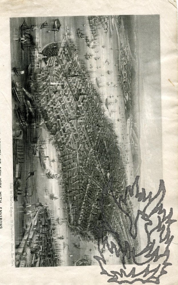
Steel engraving captioned 'Birds Eye View of the City and County of New-York with Environs.'

Author: 
Charles Magnus (1826-1900), German-born American engraver and printseller [New York; steel engraving; maps; travel; topography]
Publication details: 
[circa 1855] 'Sold by Charles Magnus, 12 Frankfort Street, New York.'
£80.00

Dimensions of print 11.5 x 19.5 cm. At the head of the recto of the first leaf of a bifolium (leaf dimensions 28 x 22.5 cm). The print itself is clear and undamaged, on aged paper. With traces of cuttings mounted onto the internal pages, and closed tear to the blank second leaf. An impressively detailed engraving, showing the bustling port and layout of the city, with church spires and prominent buildings. A copy of the item survives used as a letter home from a German girl in 1855. The copy in the New York Public Library is ascribed to 'C. Magnus, Lith. 22 N. William St.'

Three printed plans (numbered 1, 2 and 3) each entitled "Plan of Property in the Isle of Ely belonging to the Master, Fellows and Scholars of Clare College, Cambridge. To be sold by auction by Messrs. Bidwell & Sons. June, 1912."

Author: 
Bidwell & Sons, Surveyors & Auctioneers [Clare College, Cambridge; Isle of Ely, Cambridgeshire]
Publication details: 
All three plans by Bidwell & Sons, Surveyors & Auctioneers, Ely; & 11, Benet Street, Cambridge. 1912.
£120.00

Each plan printed in black on one side of a piece of paper, with areas picked off in blue, green, orange, pink and yellow. Plan No. 1: 72 x 86 cm. Plan No. 2: 88 x 68 cm. Plan No. 3: 76 x 89 cm. The first two very good on lightly aged and creased paper; the third as the first two apart from some wear along a crease resulting in two areas of loss each roughly 2 1/2 x 1 1/2 cm. The various properties (over seventy lots) are numbered, with names of the proprietors of neighbouring estates given.

Syndicate content